
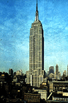
The Empire State Building
 |
HISTORY
Construction of the Empire State Building began in March of 1930 on the site of the old Waldorf-Astoria Hotel at 350 Fifth Avenue at 34th Street. It was completed 14 months later in May, 1931. Designed by the architectural firm of Shreve, Lamb, & Harmon Associates, the Empire State Building, at 102 stories, was the tallest building in the world until the completion of the first tower of the World Trade Center in Lower Manhattan in 1972.
Construction of the Empire State Building began in March of 1930 on the site of the old Waldorf-Astoria Hotel at 350 Fifth Avenue at 34th Street. It was completed 14 months later in May, 1931. Designed by the architectural firm of Shreve, Lamb, & Harmon Associates, the Empire State Building, at 102 stories, was the tallest building in the world until the completion of the first tower of the World Trade Center in Lower Manhattan in 1972.
LOCATION
350 Fifth Avenue, between 33rd and 34th Streets, New York, NY 10001
350 Fifth Avenue, between 33rd and 34th Streets, New York, NY 10001
DESCRIPTION
Architects: Shreve, Lamb & Harmon Associates.Builders: Starrett Brothers & Eken, Inc.
Height: 1,472 feet (448 meters) to top of antennae. 1,250 feet (391 meters) to 102nd floor observatory. 1,050 feet (320 meters) to 86th floor observatory.
Volume: 37 million cubic feet.
Area of Site: 83,860 square feet.
Cost including land: $40,948,900.
Cost of building alone: $24,718,000 (expected cost of $50 million
did not materialize due to the Great Depression)
Construction schedule:
Excavation: Begun January 22, 1930, before demolition of old Waldorf-Astoria Hotel completed.
Construction: Begun March 17, 1930. Framework rose at the rate of 4.5 stories per week.
Cornerstone: Laid by Alfred E. Smith, former governor of New York, September 17, 1930.
Masonry completed: November 13, 1930.
Official opening: May 1, 1931, by President Herbert Hoover, who pressed a button in Washington, D.C. to turn on the building's lights.
Total time: 7 million man hours, 1 year and 45 days work, including Sundays and holidays.
Work Force: 3,400 during peak periods.
Building Materials:
Exterior: Indiana limestone and granite, trimmed with aluminum and chrome-nickel steel from the 6th floor to the top.
Interior lobby: Ceiling high marble, imported from France, Italy, Belgium and Germany.
The Itaipu Dam
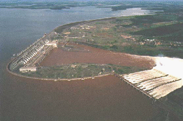 |
The Itaipú hydroelectric power plant is the largest development of its kind in operation in the world. Built from 1975 to 1991, in a binational development on the Paraná River, Itaipú represents the efforts and accomplishments of two neighboring countries, Brazil and Paraguay. The power plant's 18 generating units add up to a total production capacity of 12,600 MW (megawatts) and a reliable output of 75 million MWh a year. Itaipú's energy production has broken several records over the recent years, after the last generating unit was commissioned in 1991. The generation of 77.212.396 MWh a year in 1995 will again be surpassed in 1996, and the new record will be around the 80 million MWh a year mark.
The magnitude of the project can also be demonstrated by the fact that in 1995 Itaipú alone responded for 25% of the energy supply in Brazil and 78% in Paraguay. The power plant is also a major tourism attraction in the Foz do Iguaçú area, having received around 9 million visitors from 162 countries. The Brazilian city of Foz do Iguaçu, also home of the famous Iguaçú Falls, is located at the Western tip of Paraná State, right by the border with Paraguay and Argentina.
General Outline of the Project
The Itaipú hydroelectric power plant, located 14 kilometers North of the International Bridge linking the cities of Foz do Iguaçú, Brazil, and Ciudad del Este, Paraguay, consists of a series of various types of dams a total distance of 7,744 meters with a crest elevation of 225 meters. The Powerhouse is located at the toe of the main Dam, most of it on the river bed and the rest on the Diversion Channel. The nominal power of the plant is 12,600 MW, divided between 18 generating units of 700 MW each, 15 of which are located in the main Powerhouse and the remaining three on the Diversion Channel. The Spillway is located on the right bank, and it has 14 segmented sluice-gates with a total discharge rate of 62,200 cubic meters per second (twice that of the highest flood- level on record). The Concrete Main Dam is of the hollow gravity type and is connected to the Spillway by a concrete buttress-type Wing Dam which continues thereon as a small Cardhfill dike. On the left bank a Rockfill Dam is linked to the Main Dam and at the other end to an Earthfill Dam. In order to build the main dam wall and the Powerhouse, the river was diverted through a Diversion Channel on the left bank.
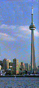
The volumes of construction in Itaipú are also impressive. The volume of iron and steel utilized in the Dam structure would be enough to build 380 Eiffel Towers, and the volume of concrete used in Itaipú represents 15 times the volume utilized to build the Channel Tunnel between France and England. Itaipú is one of the Seven Wonders of the Modern World, according to a worldwide survey conducted by the American Society of civil Engineers (ASCE) and published in Dec. 1995 as a cover article of the North-American "Popular Mechanics". The article says that " To build [the Itaipú Dam], workers reenacted a labor of Hercules: they shifted the course of the seventh biggest river in the world (Paraná River, at the Brazil/Paraguay border) and removed more than 50 million tons of earth and rock." According to the magazine, "the true marvel of Itaipú, though, is its powerhouse ... a single building that puts out 12,600 megawatts -- enough to power most of California". The CN Tower
 |
It is fitting that television, the technological wonder that profoundly changed life in the 20th century, spurred the building of the era's tallest freestanding structure. In the late 1960's, Toronto's soaring skyline began to play havoc with signals from conventional transmission towers. Signals bouncing off the city's skyscrapers produced a number of problems, including the annoying phenomenon of "ghosting" on television sets. Weaker signals competed with stronger ones, giving viewers the effects of watching two programs at once. To improve the situation, Canadian National Railways, or CN, proposed building a transmission tower that would stand head and shoulders - and then some - above Toronto's tallest buildings.
A Toronto firm prepared the initial design, enlisting the aid of engineering experts the world over. Their original plan showed three towers linked by structural bridges. Gradually the design evolved into a single 1,815.5-foot-tall tower comprised of three hollow "legs."
Foundation work began in 1973. Giant backhoes excavated more than 62,000 tons of earth and shale to a depth of 50 feet from a along the shore of Lake Ontario in Toronto harbour. Next, prestressed concrete and reinforced steel were arranged in a Y-shaped pattern 22 feet thick. Each hollow leg of the Y would carry its fair share of the tower's 130,000-ton burden.
The foundation took only four months to complete. The tower itself presented a challenge of height never before met by the technique of poured concrete. To meet that challenge, engineers designed a huge mold known as a slip form. Concrete was poured 24 hours a day, five days a week, and as it hardened, the mold moved upward by means of a ring of hydraulic jacks. The ascending slip form gradually decreased in girth to give the tower its tapering shape.
When the tower reached the 1,100-foot mark, the builders made preparations for the SkyPod, a seven-story structure housing two observation decks, a revolving restaurant, a nightclub, and broadcasting equipment. The SkyPod is anchored by 12 steel-and-wooden brackets that were slowly pushed up the tower by 45 hydraulic jacks. Concrete formed the SkyPod's "walls," and a doughnut-shaped ring, called a radome, was added to its base to protect the delicate microwave dishes receiving radio and television transmissions. The SkyPod is reached by four high-speed, glass-fronted elevators whose rapid rise simulates a jetliner's takeoff, unless weather conditions call for a much slower ascent.
The concrete tower continues above the SkyPod, ending at the Space Deck 1,465 feet up. The Space Deck receives support from cantilevers extending out of the concrete section beneath it. After a 58-second elevator ride from the SkyPod below, visitors can enjoy breathtaking vistas from a glass-enclosed balcony. On a clear day they might be able to glimpse sites 75 miles away.
For the last phase of construction, a Sikorsky Skycrane helicopter arrived to install the tower's 335-foot communications mast. One by one the helicopter lifted about 40 seven-ton sections of the mast to the top of the tower, where workers braved blustery March winds to receive them. When the sections were in place, they were secured by a total of 40,000 bolts. Afterward, the entire mast was covered by a fiberglass-reinforced sheathing to prevent icing.
Of interest to Torontonians since construction began, the CN tower gained additional fans with the arrival of the helicopter. Nicknamed Olga, its daily schedule was printed in newspapers, and changes were announced as breaking news on radio and television. With Olga, the mast assembly took a little longer than three weeks; without Olga, the job would have lasted six months.
Completed in 1975, the tower had cost $57 million to build, a bargain compared with other modern wonders. It also boasted incredible statistics of precision and safety. During construction, surveyors' transits up to a thousand feet away focused on optical plumbs mounted on the slip-form base. The constant surveillance kept the structure an incredible 1.1 inches within plumb.
Engineers established a wind-tolerance standard for the tower of 260 miles an hour, a level well above nature's most extreme demands. Counterweights on the antenna correct for wobble in high winds. Because the tower is an easy target for lightning, copper grounding wires were installed. As a result, visitors can safely view some 75 spectacular strikes a year.
The CN Tower is a work in progress. In recent years the tower gained two new elevators to accommodate an increase in visitors. To accomplish this, the 2,579-step metal staircase was moved to the interior of the structure. In addition, a glass floor was added to the SkyPod's observation deck. Brave visitors, the majority not surprisingly children, inch out over the visual void. More often than not the experience is pronounced, "Awesome!"
Almost twice as tall as the Eiffel Tower and more than three times the height of the Washington Monument, the CN Tower has taken proud ownership of Toronto's skyline, while exorcising the ghosts from its TV sets.
The Panama Canal
 |
History:
Among the great peaceful endeavors of mankind that have contributed significantly to progress in the world, the construction of the Canal stands as an awe-inspiring achievement. The unparalled engineering triumph was made possible by an international work force under the leadership of American visionaries, who made the centuries-old dream of uniting the two great oceans a reality.
In 1534, Charles I of Spain ordered the first survey of a proposed canal route through the Isthmus of Panama. More than three centuries passed before the first construction was started. The French labored 20 years, beginning in 1880, but disease and financial problems defeated them.
In 1903, Panama and the United States signed a treaty by which the United States undertook to construct an inter-oceanic ship canal across the Isthmus of Panama. The following year, the United States purchased from the French Canal Company its rights and properties for $40 million and began construction. The monumental project was completed in ten years at a cost of about $387 million. Since 1903 the United States has invested about $3 billion in the Canal enterprise, approximately two-thirds of which has been recovered.
The building of the Panama Canal involved three main problems -- engineering, sanitation, and organization. Its successful completion was due principally to the engineering and administrative skills of such men as John F. Stevens and Col. George W. Goethals, and to the solution of extensive health problems by Col. William C. Gorgas.
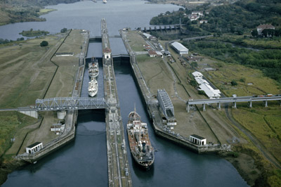
The engineering problems involved digging through the Continental Divide; constructing the largest earth dam ever built up to that time; designing and building the most massive canal locks ever envisioned; constructing the largest gates ever swung; and solving environmental problems of enormous proportions.
Now, more than 80 years after the first official ocean-to- ocean transit of the waterway, the United States and Panama have embarked on a partnership for the management, operation and defense of the Panama Canal. Under two new treaties signed in a ceremony at OAS headquarters in Washington, D.C., on September 7, 1977, the Canal will be operated until the turn of the century under arrangements designed to strengthen the bonds of friendship and cooperation between the two countries. The treaties were approved by Panama in a plebiscite on October 23, 1977, and the U.S. Senate gave its advice and consent to their ratificaton in March and April 1978. The new treaties went into effect October 1, 1979.
The Commission
The Panama Canal Commission, a U.S. government agency, will operate the Canal during the 20-year transition period that began with Panama Canal Treaty implementation on October 1, 1979. The Commission is supervised by a nine-member binational board. For the first 10 years, a U.S. citizen served as Chief Executive Officer, under the title of Administrator, and a Panamanian was the Deputy. Effective January 1, 1990, as mandated by the treaty, a Panamanian serves as Administrator and a U.S. citizen is the Deputy.
The Commission replaced the former Panama Canal Company, which, together with the Canal Zone and its government, was disestablished on October 1, 1979. On December 31, 1999, as required by treaty, the United States will transfer the Canal to Panama.
The Commission remains committed to serving world trade with the standards of excellence that have been the tradition of the waterway throughout its history. With prudent investment in maintenance, modernization and training programs, the Canal will remain a viable, economic transportation artery for world trade well into the future.
The Channel Tunnel
 |
A journey by Eurostar train through the Channel Tunnel
On December 20 1994, I travelled from London Waterloo to Paris Gare du Nord by Eurostar train, returning the same day. The journey includes travelling through the Channel Tunnel and over the new French Ligne a Grande Vitesse from the Tunnel to Paris via Lille. This account complements that by Erik Evrard, who travelled from Brussels to London on the first day of the commercial service, November 14.
I arrived at Waterloo International Terminal at 07:11 for the 08:23 departure for Paris. As my ticket wasn't valid by any other service, I wasn't taking any chances. I was in time to see the Eurostar train pull into the terminal from the depot at North Pole (near Old Oak Common on the London to Bristol line). The Waterloo International departure board showed two trains: the 08:23 to Paris and the 10:23 to Bruxelles (sic). I went down the escalator (there is also a lift) to the International concourse and a member of the Eurostar staff took my ticket and put it in the automatic gate. I walked through to the departure lounge which is very smart. As I hadn't any French money, I changed a small amount at the Bureau de Change. The cashiers were French! I then bought a cup of tea from one of the bars/cafes (there are three plus a branch of W.H.Smiths newsagent and some other shops) and the man serving me was also French. I then spoke to one of the Eurostar staff and asked her why so many of the staff were French. She said only a few of the staff were French (in a French accent) and then admitted she was also French. I have no complaints at all about this - the staff were helpful and it made me feel like I was already in France.
My train was shown on the departure screens - Platform 23 (the platform numbers continue from those of the domestic Waterloo station - there are five platforms in the International station). The screens tell you which escalator to use to reach the train depending on the number of the coach containing your seat. (All seats are reserved.) By 07:55 the terminal was filling up and the sun was up outside - I could see the road alongside the terminal through the glass walls. At about 20 minutes before departure time we were allowed up onto the platforms to board the train. Of course, I didn't immediately do so - I walked up to the platform end and asked a man to take a picture with my camera showing me standing alongside the power car. I was surprised to note that the set was based in France at Le Landy depot. The leading power car was number 3218 (those numbered 32xx are French owned) and I spoke briefly to the driver. He was also from Le Landy and he presumably stayed in England the previous night. I imagine that when the full hourly service is introduced the crews will work one trip each way starting at their home depot. I then walked back along the train to my coach (number 15). There are 18 coaches between the two power cars, in this case numbered from the London end, so my coach was near the front. The coach number and destination of the service is shown on a liquid crystal display alongside the doors which are power operated plug doors. (These slide along and then pull inwards towards the coach to close). I had a window seat, facing backwards unfortunately. Announcements were made 10 and 5 minutes before departure, first in English, then in French. (This order was reversed when we were in France.) We departed at the correct time and immediately I noticed the smoothness of the ride. There was very little noise as we ran over pointwork leaving the terminus. Our route took us through Brixton, Herne Hill, Penge Tunnel, Bromley South, Tonbridge and Ashford. In many places as we rounded curves I could see the rear of the train and appreciate the enormous length. Nowhere between London and the Channel Tunnel did we run at high speed. I wasn't able to measure speed much because I was seated on the side opposite the quarter mile posts. We ran through Tonbridge just after 09:00 and Ashford at 09:26. We passed Westenhanger (the last station before the Tunnel) at 09:32. Just before Saltwood tunnel (where the 25kV overhead wires begin) an announcement was made that we were soon to enter the Channel Tunnel and that we should advance our watches by 1 hour.
We came almost to a stand alongside the Cheriton Shuttle Terminal and we had a fine view over the toll booths, terminal area and loading platforms. Just before we entered the Tunnel a London-bound Eurostar passed us and we entered the Tunnel at 09:38. Our transit time had been annnounced as 20 minutes and we did in fact take just this time to emerge into France.
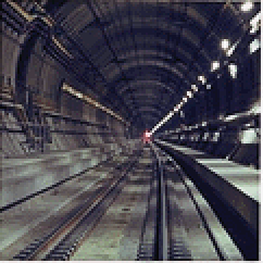
Inside the Channel Tunnel
It is surprising how much you can see and notice inside the Tunnel. I had come well prepared, having read all about the Tunnel in the British railway press, particularly the series of articles in the Railway Magazine written by Peter Semmens over the past few years. For those who don't know, the Tunnel consists of two single-line rail tunnels with a smaller service tunnel running in between. The rail tunnels are connected to the service tunnel at intervals of 375m by cross-passages with doors. There are also ducts arching over the service tunnel at 250m intervals to prevent a piston-effect and allow air ahead of a train to pass across into the other tunnel. There is full lighting throughout the tunnels but the lights in the rail tunnels are normally switched off. However, there is a light over each cross-passage door (a compact fluorescent lamp I think) and these are lit permanently. If you are seated on the correct side (the inside of the rail tunnel, nearest the service tunnel) you can see these lights quite clearly. In fact I was seated on the other side. We were travelling to France in the North Rail Tunnel (as is normal - the trains usually run on the left-hand track) and I was seated on the left side of the train facing in the direction of travel. However, I found that by lowering my head down to table level I could look across out of the windows on the opposite side and thus see the lights (just). My fellow passengers thought I was a bit mad I think until I informed them that we were travelling at 98 m.p.h. (157 km/hr) after 4 minutes in the Tunnel. At this speed you pass a cross-passage every 8.5 seconds. To calculate the speed in km/hr divide 1350 by the time in seconds. (1350 is 3/8 of 3600). For miles per hour divide again by 1.61. Soon I noticed a large pipe on the tunnel wall, and I realised that we were now under the sea. These large pipes carry cooled water from a plant on the shore at Shakespeare Cliff and the warmed water returns there for the heat to be exhausted to the atmosphere. The pipes are not present on the stretch of tunnel from the UK portal to the coast, I think. I wasn't able to see whether the same applied at the French end - I will see next time I travel through the tunnel.
The noise in the tunnel is very slight - there is a `swishing' sound of the wheels on the rails, but no noise from rail joints because the rails are long-welded.
Another thing to notice when you are in the Channel Tunnel is that yellow fire doors slide across the connection between coaches. In the open, these doors are slid back out of sight and the vestibules between coaches are open. There is a slight rise in the floor over the bogie (the coach ends are supported on a common bogie) and there are glass doors between the vestibule and the seating area. The fire doors do not prevent access to the next coach - they open if you want to walk through, but I didn't leave my seat while we were in the tunnel - there was too much to experience - so I don't know whether they open automatically as you approach.
On the outward trip I failed to see the doors dividing the cross-over caverns but I was seated on the wrong side for this. To see out I had to place my face close to the window and shield my eyes from the lights inside the train. I couldn't therefore see much out of the opposite windows.
We emerged into France at 10:58 (having advanced my watch by 1 hour while we were in the tunnel). We could see less of the Frethun Shuttle Terminal as it is farther away from the line than the English terminal although we could see a car shuttle about to come off the terminal exit line onto the tunnel approach.
High speed travel across France
From here on we really began to move fast. One of the attractions of the trip from my point of view was my first taste of 300km/hr rail travel. The Eurostar train is a TGV, although it is not marketed as such. Your ticket does say TGV though, just under the train number, because from next year the same format of ticket will presumably be used for sleeper trains which will not be TGVs. About 14 minutes after leaving the tunnel we had reached 300km/hr. I had already determined this by timing the passing of the km markers on the overhead line supports. At full speed you travel 1 km in 12 seconds and you simply divide 3600 by the time over 1 km to get your speed in km/hr. Shortly after, the Chef du Bord announced that the driver had informed him that we were now travelling at our maximum speed of 300 km/hr. When I translated this into 186 m.p.h for my fellow English travellers they were impressed by the speed, and justifiably so, because the ride was smooth and quiet. (The noise was slightly more noticeable than at 100 m.p.h, but much less than on conventional high-speed trains in Britain at 125 m.p.h.)
We passed Arras at about 11:38 and we were able to compare our speed with that of the traffic on the motorway alongside. Even the fast moving cars seemed to be travelling very slowly and the lorries seemed almost stationary. Of course we were travelling at more than THREE TIMES the speed of a typical lorry and TWICE as fast as the fast cars. Bridges simply flash past. At times we passed a train going the other way. At first I thought these were short local trains, but later I realised that they were French TGV sets travelling at full speed. We thus passed them at a relative speed of 600 km/hr and at this speed the full length of the other train is passed in less than 1.5 seconds.
The rest of the journey passed quickly and we were in Paris Gare du Nord on time at 12:23, 3 hours after leaving London Waterloo.
The journey back
I left Paris the same evening at 17:09. The arrangements at Gare du Nord are not very special, unlike Waterloo. (The French have had international trains for a long time, of course, so they don't think anything much of it.) There is a small lounge for Eurostar passengers, where I bought a cup of tea. Passengers were permitted to board the train much earlier than at Waterloo, but this is necessary because all the passengers have to pass through the same gateway (and the full capacity of a Eurostar is 794 passengers!). Two British Transport Police officers made a strange sight on the platform. I spoke to one of them and he replied that it felt strange being there at the Gare du Nord. As with the outward trip, I was again surprised to find that the set and most of the crew was French. The leading power car was 3221. It was dark soon after we left the Gare du Nord, so I couldn't see much. We reached full speed at 17:32, passed Lille at 18:07 and at 18:35 we entered the Tunnel. This time my seat was on the `inside' wall - we were in the South Rail Tunnel. Again the speed was about 100 m.p.h. (161 km/hr) and although I missed the French crossover I was able to see the yellow doors at the UK crossover about 13 minutes after entering the tunnel. Broadly the time in the tunnel at 100 m.p.h. from the French side divides into 6 minutes to the French crossover, another 6 to the UK crossover and 8 more to the UK portal. (There is more tunnel under land on the English side.)
The crossovers connect the two rail tunnels and each contains a scissors crossing housed in a huge cavern 170m long and about 18m wide. The service tunnel crosses over (or under?) the rail tunnels to run alongside the crossover cavern. Normally the two sides of the cavern are separated by steel sliding doors, but these can be rolled back to allow trains to cross from one tunnel to the other. This can be done in emergencies or during routine work on a part of the tunnel. At full speed you pass through the cavern in 3.8 seconds so if you want to see the doors you must be looking out before you reach the cavern.
We stopped in the tunnel about 4 minutes before we should have emerged into England. I was thus able to see the concrete segments and several of the cross-passage doors (labelled `EXIT SORTIE'). There are also small green illuminated arrows on the tunnel wall indicating the direction to the nearest cross-passage. I had seen these earlier but I couldn't tell what they were. I also noted that some of the tunnel workers (presumably) had been writing on the pipework and walls. I won't repeat any of what I read. Our stop was due to a cab signal we were told and we were soon moving again and emerged into England. We couldn't see much of the shuttle terminal this time, but we did see the illuminated platforms and I noted some lorries going through the toll booths. It was 19:02 British time.
The journey to London was over the same route as before and we arrived at Waterloo on time despite the stop in the tunnel.
Conclusion
I can't wait to go again. The train was superb, the high speed travel in France was exciting and it was marvellous to travel city-centre to city-centre with almost no hassle, compared to flying or taking a ferry.The North Sea Protection Works
 |
For many, the image out of the Dutch fight against the North Sea rests in the figure of a young boy valiantly saving his town by using a finger to plug a hole in the dike. But this familiar hero is a fictional one, a creation of American author Mary Mapes Dodge in her book, Hans Brinker. In reality, heroism falls on all the Dutch, who for more than a millenium have been wresting precious agricultural lands from the sea and fighting to hold on to them. Their greatest achievement-a colossal fun in the dike-if the vast and one dress project known as that Netherlands North Sea protection works.
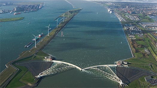
Because much of the Netherlands lies below sea level, normal tides would daily inundate about half the country if previous generations of industrious Dutch had not raised dikes and dams. Severe storms often cause tidal waters to crash into the dikes and inundate rivers and estuaries. Although all of the coastal areas are threatened, two particularly vulnerable ones are the large tidal inlet formerly known as the Zuider Zee and the delta created by the Rhine and Meuse rivers in the southwestern corner of the country.
Dutch engineers purse propose that the Zuider Zee be dammed and drained in the 19th century, but the government was reluctant to tackle such an immense project. Then, in 1916, a furious storm hit the northern provinces. The difficulties of wartime agricultural production were compounded, and the way was paved for the damming of the Zuider Zee.
The dam enclosing the Zuider Zee was built in two sections using traditional materials. Beginning in 1923, workers laid boulder clay in parallel layers and filled the space in between with sand, stones, and handmade, mattresses fashioned from brushwood. To curtail erosion, larger mattresses ballasted with chains and stones were sunk in the estuaries channels. Dredges, cranes, tugboats, and barges were engaged in the erection of the main dam, 300 feet wide at sea level and 25 feet high at the level of its causeway. As the tide turned on the final day of construction, fill tumbled into the dam's last gap, transforming the inlet into a freshwater lake, renamed the Ijsselmeer. The finished dam contains sluices for draining excess water and locks for maintaining shipping.
After the damming came the draining. In all, more than a half million acres of polders, or reclaimed farmland, emerged from the bottom of the former Zuider Zee. Young Dutch farmers clamoring for the right to settle the new polder lands, because farms on new, unobstructed land were far more suitable for modern, mechanized farming methods than traditional farms in older areas.
In 1953, the "storm of the century" howled across the North Sea and into the Netherlands, testing the strength of the Zuider Zee enclosure. It held, with damage to the causeway heavy in places. The country's unprotected southwestern provinces felt the full brunt of the storm, with water surging over seawalls and up the delta's wide waterways. More than 1,800 people lost their lives, and livestock numbering in the hundreds of thousands perished. The country then realized that the long-intended plan to safeguard the southwestern delta, the Delta Plan or Delta Project, must be mobilized.
The plan would undergo a many incarnations. The last one involved a damming four estuaries in the middle of the delta while leaving open channels to Rotterdam in the north and Antwerp, Belgium, in the south. A two-mile-long surge barrier in the Oosterschelde estuaries was the most complex and sophisticated piece of the project.
Originally, the Oosterschelde was to be a closed barrier. But lobbying by fishermen and conservationists resulted in the switch to a movable barrier. To facilitate construction, engineers fashioned islands on three sandbars in the estuaries and constructed work harbors, material yards, and work sites there. A dam connected two of the islands, effectively creating three channels in the estuaries, each to receive a section of the surge barrier.
The movable barrier consists of 65 concrete piers weighing 18,000 tons apiece. The piers support 300- to 500-ton steel gates and their hydraulic machinery, as well as a roadway above and load-bearing beams below. Constructed on the work islands, the piers and their mechanisms had to be lifted into precise positions in the estuary. But the type of equipment needed for such gargantuan and specialized tasks did not exist anywhere in the world; it had to be invented.
The Oosterschelde barrier also honored traditional methods. As part of the measures taken to stabilize the sea floor, mattresses were laid under each pier to prevent erosion. They were not the hand-built weaving of trees and brush used to close the Zuider Zee, however. Instead, they were high-tech sandwiches of sand and gravel between space-age fabric covers. The Oosterschelde project finished in 1986. Since then, the Dutch have taken additional measures, including the completion in 1997 of the barrier that protects the port of Rotterdam.
"In terms of magnitude," an American trade journal wrote, the North Sea project "approaches of the Great Wall of China. In terms of complexity and technical sophistication, it approaches the lunar shot. It is unique, expensive, and quite unlike any other civil engineering project to be found on this planet."
The Golden Gate Bridge
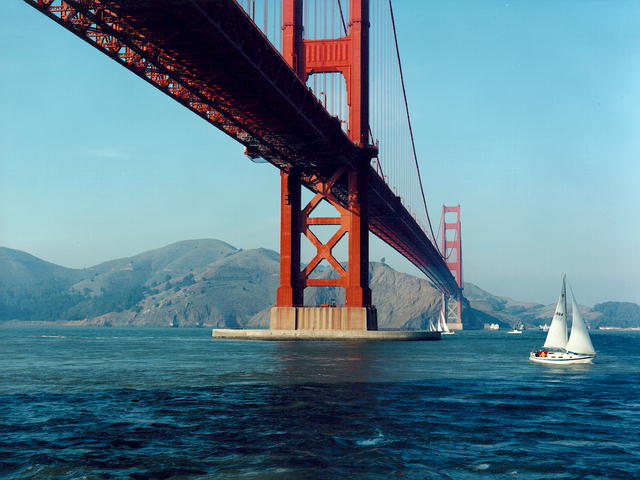 |
Before its completion in 1937, the bridge was considered impossible to build, due to persistently foggy weather, 60-mile-per-hour winds, and strong ocean currents, which whipped through a deep canyon below. In fact, the bridge is commonly known as the "Bridge that couldn't be built." Despite these unforgiving natural elements, the bridge was constructed in a little more than four years. The total cost was $35 million. The total length of the bridge spans 1.2 miles. Eleven men lost their lives during the construction of the bridge.
Even today, the massive spans of the bridge are often shrouded in fog. The bridge sways 27 feet to withstand winds of up to 100 miles per hour. International Orange was the color chosen for the bridge because it blended well with the bridge's natural surroundings. The two great cables extending from the bridge contain 80,000 miles of steel wire, which is enough to circle the equator three times. The concrete poured to cement the bridge into the stormy waters below could have also been used to pave a five-foot sidewalk from New York to San Francisco.
Because of the Golden Gate Bridge, San Francisco is one of the premier skyline cities in the nation. It was a triumphant day in the history of the city when the bridge was completed on May 27, 1937. Over 200,000 people celebrated the grand opening of the Golden Gate Bridge by walking its length. The following day, a dedication ceremony was held to officially christen what would become the architectural trademark of the city. The regular flow of vehicular traffic began the next day.
Efforts to begin the construction on the bridge began as early as 1928. The process would entail the efforts of six counties in Northern California. In 1928, the counties formed a Golden Gate Bridge and Highway District. In 1930, the voters appropriated a $35 million bond issue to finance the building of the bridge. For many years following, Joseph Baerman Strauss, a distinguished engineer, dreamed of raising a span across the Golden Gate. It was in response to his vision that people first started saying that the bridge could not be built. But, amazingly enough, Strauss held fast to his vision, and a span was eventually raised across the Golden Gate Bridge. The actual work on the bridge began on January 5, 1933. It was completed four-and-one-half years later. The result astounded the fiercest of Strauss's critics. To this day, the bridge is admired for its magnitude and beauty.
The bridge is nothing short of a powerful force meant to combat nature. The often mighty winds from the Pacific Ocean are sustained by a mid span swing of 27 feet. The two towers of the bridge rise an impressive 746 feet, which is 191 feet taller than the Washington Monument. The pier of the bridge is only 1,215 feet from the shore, the distance between the two towers that support the cables, which in turn, support the floor of the bridge is 4,200 feet. These two cables are the largest bridge cables ever made at a little over 3.61 feet in diameter.
Today, pedestrians and bicyclists are still allowed to cross the bridge on pathways with breathtaking views of the city, Alcatraz, and the Marin Headlands. The bridge toll for vehicles is $5 when entering San Francisco.
The first exit of the Marin side of the bridge is Visa Point, which provides a magnificent view of the San Francisco skyline. But, the best way to view the bridge is to walk across. This usually takes about an hour.
No comments:
Post a Comment