
The Aztec Temple
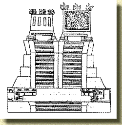 |
After the Mexicans (Aztecs) established themselves on the island of Tenoch, they were not able to build a temple worthy of HUITZILOPOCHTLI. At the begining, because of the lack of rock, they built it with sticks and hay.
Then in the times of CHIMALPOPOCA they had access to rocks, but it was not until the reign of TIZOC that the temple aquired that vision of magnificence that HUITZILOPOCHTLI paints, on the bases that MOCTEZUMA protected. Finally, the next Great Speaker AHUIZOTL, finishes and inagurates the temple in the year of 1487.
Aztec Templo Mayor (greater temple)
After the temple is finished, AHUIZOTL shared with the allied speakers and to all the nobility of these kingdoms. Even though the number of visitors and the number of sacrificed people are exagerated, there is no doubt this was the most lucid event in the history of the Aztecs.
The celebrations lasted four days, in which time all the prisoners that had been captured in four years of wars (according to the Aztecs, four towns were sacrificed) were sacrificed at the top of the temple. The prisoners were made to stand in lines to wait for their death. So many were the persons sacrificed that the people could not eat all the flesh that they were given.
The Greater Temple of the Aztecs or HUEY TEOCALLI is without a doubt one of the greatest treasures lost forever. There is nothing left standing of what the temple was; except for a few ruins, that tell us little or nothing about its greatnes.
How was this arqueological jewel in reality? There are several writings that the Spaniard conquerors left us. We have to thank that it was a custom among the conquerors to bring a writer who would describe all of their findings.
As described by Bernal de Diaz:
"...we left the great plaza without seeing it anymore and we got to the large patios and fences where the great CU (TEOCALLI) is; and there was a great circuit of patios, before getting there that seemed to be more numerous than in the plaza o Salamanca, and with two fences around it, whitewashed, and the patio and all the area around it was dappled with large white polished stones, and where there were no stones everything was whitewashed and polished in such a way that none of us found a stick nor dust on it at all. And since we came near the great CU, before we climbed a step, the great Moctezuma from up there, where they were making sacrifices, six PAPAS and two PRINCIPALES (priests) to accompany our captain, and in the process of climbing the steps, 114 in total, they were going to hold him by the arms, thinking he would get tired, just as they helped their lord Moctezuma, but Cortes did not want them to aproach him.[...]And then he took him by the hand (Moctezuma) and told him to look at his great city and all the other cities that were on the water, and many other towns that were around the same lake, on the land; and that if we had not seen his great plaza, that from up here he could see very well, and like that we stood looking, because from that big and damned temple that was so tall that he could brag everything quite well..."
We have, in the same manner, Fray Bernardo de Sahagún's writings. He with great patience sat with his informants and allowed them to draw what they were narrating. Then they described what they had drawn. In contrast to Bernal's description (the description of the typical tourist who goes about explaining what he sees, without the description of the one who knows).
According to Sahagún, in his second book, there were 78 buildings related to the TEMPLO MAYOR, with 25 piramids, 5 speaking halls, the house of fasting, four QUAUHXICALLI (bowls to place the hearts of the sacrificed people), a TECCALCO (steped temple), 7 TZOMPANTLI (structures on which the skulls of the sacrificed were displayed), 2 TLACHTLI (fields for the ball game), a well and three bathrooms, two NETLATILOYAN (basements where the skins of the sacrificed people were kept), a building for the dances, nine priest houses , jails for the gods of the conquered people, arsenals, shops and other more.
In another of Sahagún's manuscript, (in the Library of the Madrid Palace ), that had not been translated with the other writings, 15 arquitectural structures are numbered, under the title of: IN TLEIN ITOTOCA CATCA ICECECNI TLACATECOLOCALCO, or, THESE ARE THE NAMES OF THE HOUSES OF THE DIVERSE WIZARDS, that were identified on the drawing next to the writing, according to the letters that appear there:
The Banaue Rice Terraces
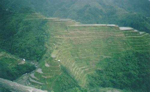 |
In Luzon Province of the Northern Philippines, through mountains and rice terraces, the road ends at a church, in a small town called Banaue. 4,000 feet above sea level in Banaue sits a small market village in Ifugao province. Located north of Manila in the Philippines, Ifugao province is famous for the handiwork of its people, who increased cultivable lands by carving gigantic rice terraces from the sides of mountains. For over 2,000 years, the people of Batad have built these terraces, one stone at a time. This growing, living stairway stretches far beyond what the eye can see. Taking an estimated 2,000 years to build, the still-productive rice terraces rise from the valley floor to heights of up to 3,000 feet, a feat of engineering so substantial that some call them the eighth wonder of the world. The only man made wonder which was literally sculpted from the earth. A scarcity of water has led to some rice patties drying up.
With no electricity or road, the people of Batad live their lives as they have for thousands of years, with a deep, close connection to the earth. They worship ancestral spirits, sacrificing three chickens or one pig to appease an angry spirit. When a person dies, the body is hung from the thatched roof of their hut for three days as a sign to the villagers that the person has moved on to a better place. Afterwards, the bones of a deceased family member are collected and placed ceremoniously inside the roof of the family's dwelling, to give comfort and protection to the living.
BOROBUDUR TEMPLE
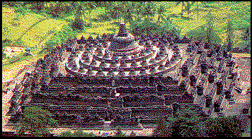 |
The expression of experts who had been studying Borobudur Temple varied someway. Bernet Kempers' expression was: "Borobudur is Borobudur", meaning that Borobudur Temple is very unique in her own way. Nieuwenkamp (an artist) imaginated Borobudur as "a big lotus flower bud ready to bloom" which was "floating" on a lake. Nieuwenkamp’s imagination was supported by N. Rangkuti (1987) that from the air, the Borobudur Temple looks floating. From the geological studies, experts were able to prove that Borobudur area was one time a big lake. Most of the villages around Borobudur Temple were at the same altitude, 235 meters above the sea-level. The same altitude included the Pawon and Mendut temples. Thus the area under 235 meter altitude was below the lake water level.
LOCATION
This temple is located at Borobudur District, South of Magelang, Central Java.
This temple is located at Borobudur District, South of Magelang, Central Java.
HISTORY
Based on the inscription dated 842 AD, Casparis suggested that Borobudur was one time a place for praying. The inscription stated a phrase such as: “Kawulan i Bhumi Sambhara”. Kawulan means the origin of holiness, "bhumi sambhara" is a name of a place in Borobudur. Paul Mus stated that Borobudur Temple had the structure of stupa (conical form) with double expression. As a whole, the Borobudur Temple was an open-flat stupa, but on the other hand, the temple expressed the idea of a “closed world”. The latter expression could be felt when one is already inside the temple. Whenever person is inside the temple, his or her view will be limited to high walls full on relieves, the verandah is always squared in such a way that one could not see other parts of the temple, even in a same floor. The same feeling happened if one stood on arupadhatu round platform, he or she will have a wider view only on that level, but are not able to see the lower level nor the upper level like the one on rupadhatu and kamandhatu. It could be said that Borobudur is a symbol of cosmic mountain covered by the sky roof, a specific world that could be reached through isolated alleys as stages. The closed structural design of the temple expressed the concept of a closed world, not just a technical reasons as had been suggested by other experts ( Daud AT, 1987)
Based on the inscription dated 842 AD, Casparis suggested that Borobudur was one time a place for praying. The inscription stated a phrase such as: “Kawulan i Bhumi Sambhara”. Kawulan means the origin of holiness, "bhumi sambhara" is a name of a place in Borobudur. Paul Mus stated that Borobudur Temple had the structure of stupa (conical form) with double expression. As a whole, the Borobudur Temple was an open-flat stupa, but on the other hand, the temple expressed the idea of a “closed world”. The latter expression could be felt when one is already inside the temple. Whenever person is inside the temple, his or her view will be limited to high walls full on relieves, the verandah is always squared in such a way that one could not see other parts of the temple, even in a same floor. The same feeling happened if one stood on arupadhatu round platform, he or she will have a wider view only on that level, but are not able to see the lower level nor the upper level like the one on rupadhatu and kamandhatu. It could be said that Borobudur is a symbol of cosmic mountain covered by the sky roof, a specific world that could be reached through isolated alleys as stages. The closed structural design of the temple expressed the concept of a closed world, not just a technical reasons as had been suggested by other experts ( Daud AT, 1987)
Borobudur was built by Sanmaratungga in the 8th century, and belongs to Buddha Mahayana. Borobudur was revealed by Sir Thomas Stanford Raffles in 1814. The temple was found in ruined condition and was buried.
DESCRIPTION
The overall height was 42 meters, but was only 34.5 meters after restoration, and had the dimension of 123 x 123 meters (15,129 square meters). There were 10 floors. The first floor up to the sixth floor was square form, the seventh to the tenth floor were round form.
The overall height was 42 meters, but was only 34.5 meters after restoration, and had the dimension of 123 x 123 meters (15,129 square meters). There were 10 floors. The first floor up to the sixth floor was square form, the seventh to the tenth floor were round form.
Borobudur is facing to the East with a total of 1460 panels (2 meters wide each). Total size of the temple walls was 2500 square meters, full of relief. The total number of panels with relief was 1212. According to investigations, the total number of Buddha statue was 504 including the intact and damaged statues. The temple undergone restoration from 1905 to 1910, and the last restoration was done in 1973 to 1983.
Ever since the first excavation, most experts speculated on the exact shape of the temple. Hoenig, in his book "Das form problem des Borobudur" speculate that the original form of Borobudur Temple had four gates and nine floors. The form of Borobudur Temple is similar to temples found in Cambodia. According to Parmenteir, the huge single stupa on top of the temple made the smaller stupas in the lower part looked drowned. Stutterheim who had been studying stupas in India and other parts of Asia concluded that the stupa structure was an Indian origin. The original purpose of stupa building was as storage of Buddha Gautama and other holy priests cremation ash.
According to Stutterheim, the overall form of Borobudur Temple is a combination of zigurat (middle Asian Pyramid) and Indian stupa. Stutterheim opinion was supported by the existence of this type of form in Ancient Javanese literature.
The relief of Borobudur temple started from the base of the temple up to the fourth platform. The relieves at the base contained the story of Karmawibhangga. Under the main panel and above the Karmawibhangga relief, a wide-sized relief was inscripted at the wall. From this point along the alley, the relief did not show story in the sequence, but as a repeating part of the story with the same motives which expressed the world of spiritual beings such as half demonic body (Gandharwa, giants or Yataka, dragon, Sidha or angels and their ladies friends, Apsara and Nagi, all of them are heavenly beings who are tender and beautiful.
Division of panels are: the first panel expressed a heavenly being in sitting position, on both side of this panel are small panel with a small standing statue. This figures are repeated 26 times for each side of the wall. Between the panels is carved three bodies, a male flanked by two women.
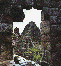
The Inca City of Machu Picchu
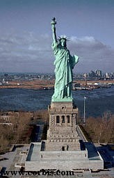
The Statue of Liberty
The Mayan Temples of Tikal
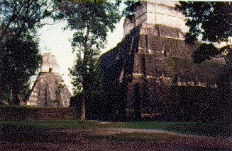 |
The Maya ruins of Tikal are hidden deep in the rainforests of Guatemala. From the air only a handful of temples and palaces peak through the canopy. The stone carvings are weather-beaten. Huge plazas are covered in moss and giant reservoirs are engulfed by jungle. The only inhabitants are wild animals and birds. However, 1200 years ago, Tikal was one of the major cities of the vast and magnificent Maya civilisation that stretched across much of what is now southern Mexico, Belize and Guatemala. Tikal was home to perhaps 100,000 people. Thatched farmsteads and fields would have stretched as far as the eye could see.
The Maya world had thrived for nearly 2000 years. Without the use of the cartwheel or metal tools, the Maya had built massive stone structures. They were accomplished scientists. They had tracked a solar year of 365 days and one of the few surviving ancient Maya books contains tables of eclipses. From observatories, like the one at Chichen Itza, they tracked the progress of the war star, Venus. They developed their own mathematics, using a base number of twenty, and even had a concept of zero. They also had their own system of writing. So stable and established were they, that they even had a word for a 400-year time period. Maya society was vibrant, but it could also be brutal. It was strictly hierarchical and deeply spiritual. Humans were sacrificed to appease the gods. The elite also tortured themselves. Male Maya rulers perforated the foreskins of their penises and the women their tongues, apparently in the hope of providing nourishment for the gods who required human blood.
However, in the ninth century, their world was turned upside down. Many of the great centres like Tikal were deserted. The sacred temples and palaces briefly became home to a few squatters, who left household rubbish in the once pristine buildings. When they too left, Tikal was abandoned forever - the Mayan civilization never recovered. Only a fraction of the Maya people survived to face the Spanish conquistadors in the 16th century. For decades, archaeologists have been searching for an explanation of the Maya collapse. Many theories have been put forward, ranging from warfare and invasion to migration, disease and over-farming. Many think the truth may lie with a combination of these and other factors.
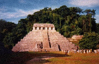
The Temple of the Inscriptions
 |
Situated at the eastern edge of the Rio Usumacinta Basin in the foothills of the Sierra Oriental de Chiapas at an elevation of slightly less that 3000 m, Palenque looks out on a low coastal plain extending to the Gulf of Mexico about 130 km. to the north. See Map 1.
The climate is warm (median temperature 26 C) and humid (average annual precipitation 2156 mm) with little seasonal variation and showers during the entire year.
Surrounded by dense forests dominated by mahogany, cedar and sapodilla trees, frequently shrouded in fog, the ruins are among the most aesthetically impressive in Mesoamerica.
Palenque represents the western regional variant of Classic Maya civilization. Although the earliest occupation of the site dates to about 100 BC, it becomes a major population center only at about 600 AD and all construction at the site has ceased by about 800 AD. The ruins now visible are the heavily restored remains of the ceremonial center (Map 2) of a more extensive settlement (Map 3) bordered by agricultural fields.
The ceremonial center may be divided into three major areas:
- an open area bounded by the Pyramid of the Inscriptions, the west facade of the Palace and the unexcavated mound Temple XI;
- separated from area 1) by the, canalized and partly vaulted, Arroyo Otulum and at a significantly higher elevation an area bounded by the Temple of the Sun, the Temple of the Cross and the Temple of the Foliated Cross;
- an area somewhat lower in elevation than area 1, including the Ball Court and the Temple of the Count, bounded by the north facade of the Palace, Temple X, and the North Group.
Information obtained from inscriptions on the structures relates their construction to the rulers of Palenque.
Pacal assumed power in 603 AD at the age of 12 and ruled for 68 years until his death in 683 AD. In 647 AD he built the Forgotten Temple. located some .5 km south of the Palace. (then somewhat less extensive than its final form). He also constructed the Temple of the Count, as well as underground galleries beneath corbled passages in the Palace. Stucco reliefs of masks in tableros on the west end of the north facade of the Palace and figures with well defined facial features on columns on the north facade celebrate Pacal's ancestry. (Map 4)
Pacal's remains, adorned with jade ornaments and face covered with a jade mask were deposited in a stone sarcophagus covered with an elaborately carved stone located in a chamber 1.5 m below the surface of the plaza above which was erected the Pyramid of the Inscriptions The sarcophagus is accessible by a stairway from Temple of the Inscriptions on the top of the pyramid.
Chan-Balum, Pacal's eldest son, assumed power in 684 AD upon the death of his father and ruled for 18 years. He was responsible for the completion of the temple atop the Pyramid of the Inscriptions modeled after the Forgotten Temple and the construction of the Group of the Cross temples: the Temple of the Cross, the Temple of the Foliated Cross, and the Temple of the Sun. The panels on the rear interior walls of all these temples depict Chan-Balum and Pacal containing texts purporting to legitimate Chan-Balum's power.
Kan-Xul the younger son of Pacal succeeded his older brother in 702 AD at the age of 38 and ruled for 23 years. He remodeled the Palace adding rooms, galleries and courtyards with bas-relief slabs some exhibiting fine detail.
Under Kan-Xul's direction the Palace assumed roughly its present form including T-windows (also present in other structures at Palenque and at other sites) whose function is unclear. The T-form also appears in the Ik day glyph which means `wind" and `breath" and might be taken as a metaphor for `life'.
Kan-Xul may also been responsible for adding the tower to the Palace. This structure supported by wooden lentils with an interior staircase is thought by some to have functioned as an astronomical observatory, a theory supported by the presence of a venus glyph on a landing.
Temple XIV is also attributed to Kan-Xul. This structure, was apparently deliberately placed to block access to the Group of the Cross.
Kan-Xul is thought to have been made a prisoner of war and decapitated.
Though the occupation of Palenque continues until 799 AD, most of the presently visible ruins were constructed prior to the death of Kan-Xul.
The Throne of Persepolis
 |
Founded in the Sixth Century BC by the Kings of the First Persian Empire (the Achaemenids), Persepolis is located 60 km northeast of Shiraz in Iran. The present-day Persian name, Takht-e-Jamshid, means "Throne of Jamshid", a legendary Iranian King. However, the ancient name of the city was Parsa, or Pars' City, hence the Greek name Persepolis.
Construction of the city began under Kings Cyrus the Great (ca. 550 BC) and Darius I (ca. 520 BC) to possibly serve as a ceremonial and spiritual Capital of the Persian Empire. Susa, the administrative Capital, was located 500 km north of Persepolis. The growth of the city continued under later Kings such as Artaxerxes I (ca. 450 BC) who finished the Hall of 100 Columns and Artaxerxes II (ca. 350 BC) who built the Unfinished Palace. However, the most glorious monuments in Persepolis were commissioned by Xerxes I (ca. 470 BC): the Gate of All Nations, and the Throne Hall.
Persepolis continued to flourish under the later Achaemenian Kings, until it was burned and destroyed by Alexander the Great in 330 BC. It is not known whether the burning of the city was accidental, or an act of revenge for the destruction of Temples in Athens in 480 BC by the Persians.
Modern excavations in Persepolis began in the early 19th Century. The Gate of All Nations is located at the end of two monumental staircases. Between the staircase ramps are symbols of the Zarathustrian God Ahura Mazda, and carvings representing the different Nations of the World, from Egyptians and Armenians, to Babylonians, Assyrians, and Medians. The Gate leads to the Throne Hall, or the Hundred-Column Hall. The Hall contains several doorways adorned with carvings showing the King in military combat. It is believed that the Gate of All Nations and the Throne Hall were used in New Year's celebrations when delegates presented the annual tribute to the Persian King. The city of Persepolis was declared a World Heritage Site by the UNESCO in 1979. PETRA
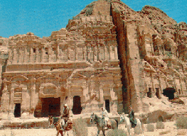 |
Petra (lit. Rock) was the capital city of the Nabataeans, a tribe of pre-Roman Arabs who dominated the region around the Sixth century BC. Located at the crossroads of ancient trade routes, the city survived on toll and taxes collected from traders. Despite several attempts to conquer their capital, the Nabataeans remained practically independent until the defeat of Antony and Cleopatra and the reunification of the Roman Empire by Octavian in 31 BC. In 106, the Romans under Trajan finally captured Petra to mark the beginning of the decline of the city. The city remained unknown to the Western World for hundreds of years until a Swiss explorer, J.L. Burckhardt, heard about its existence from the local Bedouins in 1812.
The Nabataeans carved their Capital in the canyons and hills of sandstone of Wadi Araba in Jordan. The entrance to the city is through The Alley (Al-Siq), a winding trail at the bottom of the canyon. Most famous is The Treasury (Al Khazneh), which fascinating façade was featured in many movies. Carved in the pink sandstone, the structure is 40 m high and about 30x30 m wide. Its architecture has been certainly strongly influenced by the Romans, which suggests it was built around the First century AD. The city includes other fascinating monuments and structures, such as Urn Tomb and the Royal Tombs, the Colonnade Street, the Temples of Dushara and Al-Uzza, and the High Place of Sacrifice. The Suez Canal
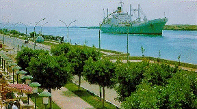 |
The idea of a canal linking the Mediterranean to the Red Sea dates back to ancient times. Unlike the modern Canal, earlier ones linked the Red Sea to the Nile, therefore forcing the ships to sail along the River on their journey from Europe to India. It has been suggested that the first Canal was dug during the reign of Tuthmosis III, although more solid evidence credits the Pharaoh Necho (Sixth Century BC) for the attempt. During the Persian invasion of Egypt, King Darius I ordered the Canal completed. The Red Sea Canal, consisted of two parts: the first linking the Gulf of Suez to the Great Bitter Lake, and the second connecting the Lake to one of the Nile branches in the Delta. The canal remained in good condition during the Ptolemaic era, but fell into disrepair afterwards. It was re-dug during the rule of the Roman Emperor Trajan, and later the Arab ruler Amr Ibn-Al-Aas. Over the years, it fell again into disrepair, and was completely abandoned upon the discovery of the trade route around Africa.
It was Napoleon's engineers who, around 1800 AD, revived the idea of a shorter trade route to India via a Suez Canal. However, the calculation carried out by the French engineers showed a difference in level of 10 meters between both seas. If constructed under such circumstances, a large land area would be flooded. Later, the calculations showed to be wrong, and the final attempt to dig the Canal was undertaken by former French Consul in Cairo and famous Canal digger Ferdinand de Lesseps. He was granted a "firman" or decree by the khedive Said of Egypt to run the Canal for 99 years after completion.
In 1859, Egyptian workers started working on the construction of the Canal in conditions described by historians as slave labor, and the project was completed around 1867. On November 17, 1869, the Canal was officially inaugurated by Khedive Ismail in an extravagant and lavish ceremony. French, British, Russian, and other Royalty were invited for the inauguration which coincided with the re-planning of Cairo. A highway was constructed linking Cairo to the new city of Ismailia, an Opera House was built, and Verdi was commissioned to compose his famous opera, "Aida" for the opening ceremony. Ironically, Verdi did not complete the work in time and "Aida" premiered at the Cairo Opera a year later.
The Suez Canal emerged on the political scene in 1956, during the Suez crisis. It was in July of that years the Egyptian president Nasser, at age 38, announced the nationalization of the Canal at Mansheya Square in Alexandria in front of a cheering crowd. His decision was in response to the British, French, and American refusal for a loan aimed at building the Aswan High Dam. The revenue from the Canal, he argued, would help finance the High Dam project. The announcement triggered a swift reaction by Great Britain, France, and Israel, who all invaded Egypt less than two months later. Their action would be condemned by the International community, and Nasser would eventually claim victorious.
In 1967, the Canal was closed at the wake of the Six-Day War, when Israel occupied the Sinai Peninsula, causing the Canal to act as a buffer zone between the fighting forces. The Egyptians reclaimed the Canal upon the 1973 Arab-Israeli War, and the re-opening ceremony took place in 1975. Since then, the Canal, which stretches 167 kms across the Egyptian desert, has been widened twice. Today, approximately 100 ships cross the canal daily, and, with the threat of war long gone, the cities and beaches along the Bitter Lakes and the Canal serve as a summer resort for tourists.
The Sydney Opera House
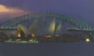 |
Surrounded by water on three sides, at what is known as Bennelong Point, stands one of the most magnificient buildings on one of the most beautiful harbours in the world. The Sydney Opera House, originally designed by the Danish Architect Joern Utzon, is meant to look like a giant sailing ship.
Since its opening in 1973, the Sydney Opera House has been host to some of the most memorable artistic performances. We cannot hope to match its marvelous accoustics here, or to create the great sensation of being close to this landmark. It is however our hope that you will enjoy your virtual tour of the Opera House and decide to visit soon.
The Red Fort in India
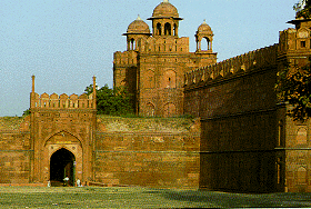 |
The largest of old Delhi's monuments is the Lal Quila, or the Red Fort, the thick red sandstone walls of which, bulging with turrets and bastions, have withstood the vagaries of time, and nature. The Lal Quila rises above a wide dry moat, in the northeast corner of the original city of Shahjahanabad. Its walls extend up to two kilometers, and vary in height from 18 meters on the river side to 33 meters on the city side.
Mughal Emperor Shahjahan started the construction of the massive fort in 1638, and work was completed in 1648. The fort sports all the obvious trappings, befitting a vital centre of Mughal government: halls of public and private audience, domed and arched marble palaces, plush private apartments, a mosque, and elaborately designed gardens. Even today, the fort remains an impressive testimony to Mughal grandeur, despite being attacked by the Persian Emperor Nadir Shah in 1739, and by the British soldiers, during the war of independence in 1857.
Entrance to the fort is through the imposing Lahore Gate, which as its name suggests faces Lahore, now in Pakistan. This gate has a special significance for India, since the first war of independence, and has been the venue of many an important speech, delivered by freedom fighters and national leaders of India.
The main entrance opens on to the Chatta Chowk, a covered street flanked with arched cells, that used to house Delhi's most skilful jewelers, carpet makers, weavers and goldsmiths. This arcade was also known as the Meena Bazaar, the shopping centre for the ladies of the court. Just beyond the Chatta Chowk, is the heart of the fort called Naubat Khana, or the Drum House. Musicians used to play for the emperor from the Naubat Khana, and the arrival of princes and royalty was heralded from here.
The Fort also houses the Diwan-i-Am or the Hall of Public Audiences, where the Emperor would sit and hear complaints of the common folk. His alcove in the wall was marble-paneled, and was set with precious stones, many of which were looted, after the Mutiny of 1857. The Diwan-i-Khas is the hall of private audiences, where the Emperor held private meetings. This hall is made of marble, and its centre-piece used to be the Peacock Throne, which was carried away to Iran by Nadir Shah in 1739. Today, the Diwan-i-Khas is only a pale shadow of its original glory, yet the famous Persian couplet inscribed on its wall reminds us of its former magnificence: "If on earth be an Eden on bliss, it is this, it is this, none but this."
The other attractions enclosed within this monument are the hammams or the Royal Baths, the Shahi Burj, which used to be Shahjahan's private working area, and the Moti Masjid or the Pearl Mosque, built by Aurangzeb for his personal use. The Rang Mahal or the 'Palace of Colors' housed the Emperor's wives and mistresses. This palace was crowned with gilded turrets, delicately painted and decorated with an intricate mosaics of mirrors, and a ceiling overlaid with gold and silver, that was wonderfully reflected in a central pool in the marble floor.
Even today, the Lal Quila is an eloquent reminder of the glory of the Mughal era, and its magnificence simply leaves one awestruck. It is still a calm haven of peace, which helps one to break away, from the frantic pace of life outside the walls of the Fort, and transports the visitor to another realm of existence.
The Red Fort of Agra is perhaps one of the most magnificent specimens of Mughal architecture which portrays their creative and artistic genius to the fullest. It took several decades to build this extraordinary monument. The credit for this work cannot be attributed to one person alone. Three emperors, Akbar, Jehangir and Shahjehan partook in the construction at different periods of time.
The first person to start a construction in the area was Sultan Sikander Lodi who named the fort “Badalgarh”. It was Akbar who tore it down and built in its place the high red sandstone ramparts, which give the fort its name. Legend says that Akbar built more than 500 buildings, palaces and pavilions overlooking the banks of the river Yamuna within the precincts of The Red Fort. These were mostly all torn down by his grandson, Shahjehan and only the “Jehangiri Mahal” still stands. The white marble palaces and courts that one sees today are mostly the work of Shahjehan.
Shahjehan completed the Red Fort, which is known as “Lal Qila” in Hindi, in 1648. The walls surrounding the fort extend for more than two kilometers and vary in height between 18 meters and 33 meters. Shahjehan built this fort because he wanted to shift his capital from Agra to Delhi. But, before he could do this, he was captured and imprisoned by his son Aurangzeb in the fort itself, where he stayed until he died.
The Red Fort is to be entered by the Delhi Gate to the west, which pierces the outer wall. After this, one goes through the “Hathi Pol” or Elephant Gate, which is a tiled and ornamented entrance that pierces the inner wall. Once inside, one sees the “Diwan-e-am” and the “Diwan-e-khas” which are pavilions where the king gave audience to the common people and the elite respectively. The “Rang Mahal” is a water-cooled apartment for the royal ladies and in the basement of the fort there is a market where one can buy traditional Indian goods at very competitive rates. The “Khas Mahal” and “Sheesh Mahal” are exquisitely ornamented halls, which portray the brilliance and splendor of Mughal royalty. There is also another entrance to the Red Fort, which is the “Lahori Gate”. This entrance leads to the well-known “Chandni Market”. In the evenings there is a special light and sound show organized for tourists which is a must see.
The Great Sphinx of Egypt
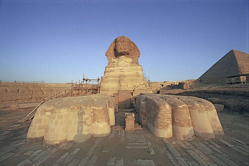 |
| The Great Sphinx of Giza (or, commonly, the Sphinx) is a statue of a reclining sphinx (a mythical creature with a lion's body and a human head) that stands on the Giza Plateau on the west bank of the Nile in Giza, near modern-day Cairo, Egypt. It is the largest monolith statue in the world, standing 241 feet long, 20 feet wide, and 66 feet high. It is the oldest known monumental sculpture, and is commonly believed to have been built by ancient Egyptians of the Old Kingdom in the reign of the pharaoh Khafra (c. 2558–2532 BC). |
| The figure was buried for most of its life in the sand. King Thutmose IV (1425-1417 BC) placed a stella, inscribed with a story, between the front paws. It describes when Thutmose, while still a prince, had gone hunting and fell asleep in the shade of the sphinx. During a dream, the sphinx spoke to Thutmose and told him to clear away the sand because it was choking the sphinx. The sphinx told him that if he did this, he would be rewarded with a kingship. Thutmose carried out this request and the sphinx held up his end of the deal. |
No comments:
Post a Comment